How the Leeds and Liverpool Canal changed Burnley


Yorkshire Street, or to be more precise, part of it, was originally known as Eastgate. As we have seen, in previous articles, Burnley had a number of streets with the word gate in their title.
Westgate and Finsley Gate are probably the best known though there is also Queensgate which originally applied, not to a road, but a row of houses.
Advertisement
Hide AdAdvertisement
Hide AdIn fact, there never has been a Queensgate as a street; the name applies to one of the newer areas of town.
Many towns had gates named after the four points of the compass. These towns were often walled cities and the gates were actually gates in the defensive walls that surrounded the town.
Burnley was not like that.
Its “gates” derive from the Old Norse, the language of the Vikings, and, in this instance, the word derives from gaeta, a path. Our town once had a Westgate and an Eastgate but the other two points of the compass were served by North Parade and South Parade.
The latter was the part of Manchester Road just above the canal and Manchester Road’s junction with what is now Trafalgar Street.
Advertisement
Hide AdAdvertisement
Hide AdIt was once one of the better areas of Burnley in which to live and there were a number of good houses there but, as the years went by, the properties became less attractive. The area declined and now only a few properties survive.
North Parade was part of what is now Bank Parade nearest its junction with Colne Road. This contained some of Burnley’s best houses and a number of them still survive, though most are now used for commercial purposes rather than housing.
If we return to the Eastgate area, there are few references to this part of town until the opening of the first section of the canal in 1796. There was, though, a road, part of the old Burnley to Rochdale Turnpike, which was bridged by the Culvert. It was this road that was known as Eastgate. To this ought to be added Gunsmith Lane, which joined Eastgate on the town centre side of the Culvert, and Chapel Street, which ran between the two.
What is clear from early references to Eastgate is that it was a pretty part of town. The Brun flowed towards Eastgate from the St Peter’s area and, just before the river turned to flow parallel to the old part of Church Street (which is now Kierby Walk) there were some stepping stones. These took pedestrians across the river, the far side of which, part of the Bank which gave Bank Parade its name, was planted with a great number of trees.
Advertisement
Hide AdAdvertisement
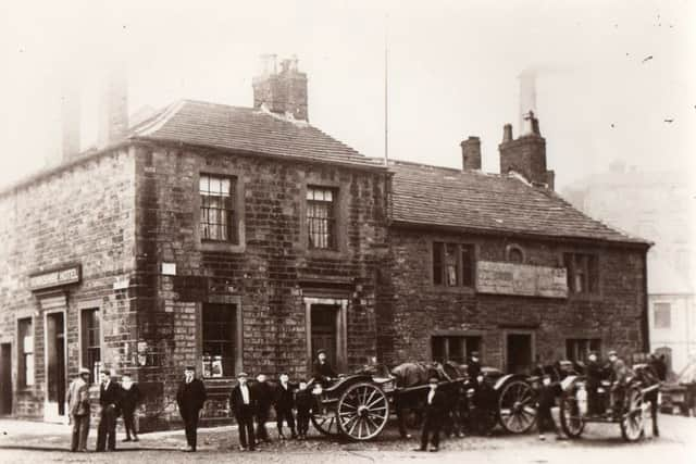
Hide AdGetting nearer to Eastgate, there were a number of gardens and orchards. A number of you will remember the Yorkshire Hotel. The first property on this site was a charming but small house surrounded by extensive gardens. There were flower beds, fruit gardens and vegetable plots but in those days – the early years of the 19th Century – many people grew some of their own food.
Others relied on what we would call market gardens and the site of what became the Keirby Brewery, built in 1823, was one of the many once located in Burnley.
Generally, the only evidence we have that market gardens existed – sometimes in the most unlikely places – is on early maps. Mostly, we do no know what was produced there and often their owners do not enter the record.
Of course, the coming of the canal made it possible to import food from other parts of the country and Burnley’s relatively small market gardens fell into disuse.
Advertisement
Hide AdAdvertisement
Hide AdHowever, even I can remember one of the last of these market gardens. It was situated in King’s Causeway, Brierfield, just below Nelson Golf Club, and produced the strange combination of rhubarb and cress. So much of the latter was grown that, briefly, East Lancashire Railway was know as the “Watercress Line” and I recall Brierfield station platform piled high with boxes of cress waiting to be sent to Preston.
Mention of the coming of the canal is significant in the Eastgate part of town. It arrived in two separate sections opened at different times, the first in 1796 when the canal was opened to the Culvert from the east or Colne direction. It was this event which changed the Eastgate area. Burnley was a significant importer of lime which was largely used for building. The canal opened up large beds of limestone near Barnoldswick and perhaps the first developments on the canal bank were the two great lime kilns near the Culvert.
As many of you know, the best known of the kilns was restored by Sainsbury’s when they occupied their supermarket at the top of what was Gunsmith Lane, but there is a better example of a lime kiln just behind Culvert Buildings which are in present day Yorkshire Street. Not all of the structure has survived but if you want to see how big they were, walk behind Culvert Buildings and you can’t miss them.
Perhaps the second development which was a result of the coming of the canal was the construction of the Rope Walk parallel to the canal just before the canal gets to the Culvert. The making of rope is an industry which has not received very much attention from historians but the rope walk here dates from the 1790s and was constructed because of its proximity to the canal.
Advertisement
Hide AdAdvertisement
Hide AdA rope walk needed a long straight stretch of land upon which to construct the machinery the purpose of which was to give twist to the rope and, thus, its strength. The machinery was not large or complex but it was necessary for the rope maker to walk as the hemp, or other material out of which the rope was made, was given twist. Burnley’s rope walk, one of two or three in town, was several hundred yards long and the rope was used in the local mills and mines.
The canal was an ideal conveyor of heavy goods, like coal and wheat, and it is not surprising to find there was a large coal staith near the Culvert. It served Rowley and Bee Hole Mines and provided coal for the lime kilns which were adjacent.
As might be anticipated the canal, especially, the 1802 second part (from the Culvert in the direction of Finsley Gate) was soon responsible for additional business opportunities. A number of mills were constructed adjacent to the canal not to take water from the canal but because it was cheaper to get coal to the boiler rooms of the mills by canal than it was by road. Soon cotton mills and corn mills were being built on the canal bank above and below the Culvert.
There were three corn mills, one above the Culvert at Hill Top and two below, at Pillingfield and at Basket Street. The cotton mills included the huge Rishton Mills on the Burnley side of the Culvert, now the site of the former Sainsbury’s building, but the whole of the Hill Top area was developed in quick time.
Advertisement
Hide AdAdvertisement
Hide AdI do not want to say too much about the Hill Top area. It is to be the focus of a short series of articles scheduled for this summer. However, the coming of the canal meant this area which had remained, apart from buildings in Church Street, undeveloped until the 1790s soon hosted lots of badly built and crowded houses, a number of inns and quite a few ugly industrial buildings.
Eastgate itself was the main road route out of Burnley to Yorkshire. The road, as indicated, was a turnpike and a number of mile posts have survived. The one nearest to Eastgate/Yorkshire Street can be found in the wall of Burnley Cricket Club in Harry Potts Way.
It appears the Burnley to Todmorden turnpike was built about 1759 and probably into the 1760s. It followed Eastgate, went along what is now Yorkshire Street to Brunshaw Road, via the recently named Harry Potts Way. From there it went through the now vanished village of Brunshaw, which had a tollgate, to the top of Brunshaw and on to Higher Red Lees. Just beyond there is the Ormerod estate, where by the gatehouse into the Park, another splendid mile stone can be seen. From there the road went on to Southward Bottom (a third milestone) and then to Holme Chapel, Portsmouth, Cornholme and Todmorden from where there were routes to Rochdale and Manchester, to the right, and Halifax and Leeds to the left.
This was a busy road and it predates the current Todmorden Road by some years. The early part of it (the section known as Eastgate and later Yorkshire Street) was redeveloped after the building of the canal. There were, as we have seen, a number of buildings on the Burnley side of the Culvert but the Culvert itself, and the canal, proved to be something of a barrier to the development of this part of town.
Advertisement
Hide AdAdvertisement
Hide AdTowards the end of the 19th Century, the Culvert was enlarged with the two pedestrian routes added to the central arch which carried the road but it was not until 1926 that the present Culvert was built.
Though the old Culvert might have been a barrier, do not get the idea there were no buildings on the Turf Moor side of the structure. These were restricted to a few streets for some time – Eastgate, itself, Plumb Street and Eastham Place. However, on the first mentioned there was, in the early years of the 19th Century, Burnley’s local, but unofficial, Butter Market.
We have records of local farmers – especially those from Briercliffe – travelling from their farm houses with surplus butter and cheese for sale. A little is known about the cheese sold. It appears there was the traditional Lancashire “hard” cheese which is still made, but not around here, and a soft cheese, something like a sweeter Brie.
Added to the Butter Market were a number of shops and a famous local firm of blacksmiths. The Brickmaker’s Arms came later as did St Mary’s Church with its former schools behind. Incidentally, the recently closed Brickmaker’s got its name as there was a small brick works in the area.
So there we have had a brief look at the Eastgate/Yorkshire Street area. There is much more I could have said, so perhaps we will look at this area again in future.