Historic maps give insight into Burnley’s changing landscape


Instead we are going to look at some maps but they are not just “any old maps”. These derive from a single book made in Burnley by the once well known firm of Burghope and Strange who, latterly, went by the name of George Anderson (Burnley) Ltd. They were letterpress and lithographic printers, bookbinders and manufacturing and commercial stationers and, only in the last few years, the firm closed its Standish Street shop.
In their heyday Burghope and Strange operated Parsonage Mill, on Keighley Green, which occupied part of the site now taken by St Peter’s Leisure Centre and, in addition, had what they called their “retail department” at 50 St James’s Street in town.
Advertisement
Hide AdAdvertisement
Hide AdThe first entry in the book was made in 1883, the last in 1902, and the entries themselves were made on a series of forms, with space for maps, which were used by the council to record what amounted to small planning decisions. I think this article is the first time such information has been used by a local historian in Burnley.
I decided to make use of the information in the book because of feedback I had from the article I published on Healey Wood. In it I mentioned a number of street names but did not mention exactly where they all were. I thought it would confuse readers because all of the streets contained the word “Healey”.
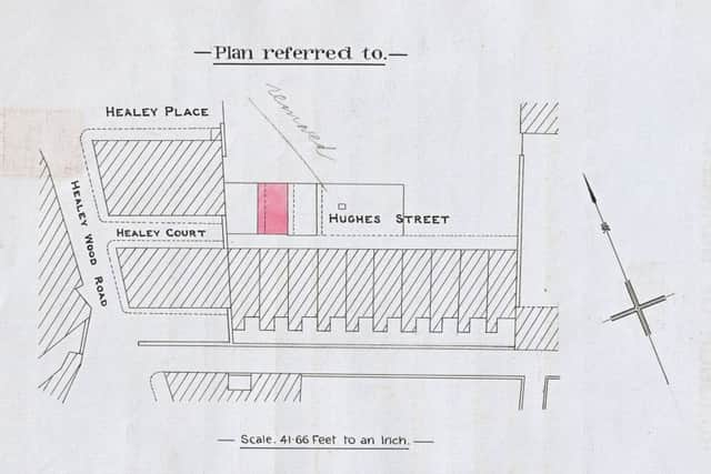
In fact it was me who was confused as I got the location of Healey Place wrong. I said it was off Woodland Street but it turns out this street was actually Marquis Place and Healey Place was where it is indicated on the first map published today. What I said about Healey Place applies to the property shown on this map. Marquis Place is recorded in the 1937 Commercial Directory and consisted of nine dwellings, five of which were occupied by retired people, all of the remaining four occupied by labourers.
The map published today was prepared in January 1893 and had been drawn up for an agreement between James Henry Heys and Akroyd Hollinrake and Burnley Council. The former wanted to enclose the portion of Hughes Street marked on the map and, for a consideration of “one shilling” to be paid on the first day of January each year; they undertook to “open out” the said Hughes Street to the public. The document is counter-signed by John Arthur Johnson who was Chief Clerk to the Town Clerk.
Advertisement
Hide AdAdvertisement
Hide AdThose of you who know the area will be aware Hughes Street is still there but neither Healey Place nor Healey Court has survived. However, you can see where they were. What is disappointing is that whoever it was that drew up the map did not take the trouble to show how many houses there were on Healey Place and Healey Court. The property between the two was certainly traditional back-to-back housing and it would have been interesting to see just how it was divided up.
The next map I have chosen is in a part of town some of which has survived. It refers to Burghley Street, off Brougham Street, Burnley. As you can see, the map, specially drawn for an application by the Burnley Tradesmen’s Billposting Co. Ltd, was produced to indicate the location new hoardings, or Bill Posting Stations, as they were called. For a consideration of one penny per square yard the company agreed to remove the hoardings at a month’s notice.
The hoardings were to be located at the junction of Berkeley Street and Burghley Street on a site close to the present Asda store. At the time of the application, made in 1893, this latter site was occupied by the Bankhouse Iron Works of George Keighley’s, Burnley loom makers. Also on the site was Albert Mill.
An illustration of how small some of these applications often were can be seen in an example in Todmorden Road, Burnley, agreed in December, 1894. In this case the application was made to remove a portion of the pier to the parapet wall of the Hand Bridge and construct a small fence wall to the garden of the adjoining house. The houses shown in the map are still standing and, of course, Hand Bridge is still in use.
Advertisement
Hide AdAdvertisement
Hide AdThe fourth example I am going to give is of an area which has long gone. It involves the Barracks Road area which was sacrificed to the building of the Burnley section of the M65. This very detailed map shows us the Barracks Road junctions with Haslam Street, bottom left; Roebuck Street, top left and Radcliffe Terrace, just of the centre of the map.
An agreement was signed by John Edward Spencer, a (commercial) traveller, of 17, Dulwich Street, and Mr J.D. Schofield, of Burnley Council, to open out an enclosed portion of Radcliffe Terrace to the use of the public. However, the utility of such a map can be seen in the detail which it offers the local or family historian. If, for example, someone researching their family history wanted to know about the houses in this long demolished part of town there is even detail about how each and every back yard is arranged.
The large building, right in Haslam Street, was St Mary Magdalene RC Junior School. The Infant School, further to the right, was yet to be built.
An area of town that has not changed all that much is the Westgate/Wiseman Street area and an agreement signed in 1901 gives us a splendid image of this district. You can see the Burnley Tramway “from Burnley to Padiham” is very much in use and the houses shown in Westgate remain very much the same today as they were in 1901. The large building at the corner of Wiseman Street and Westgate has been turned into a shop which has served in recent years as a kitchen showroom.
Advertisement
Hide AdAdvertisement
Hide AdAt the top of Wiseman Street, on the right, you can see what is described as a “Lodge”. This is a reference to the mill pond of Oakmount Mill which is still used for textile purposes, though as a mill shop. On the other side of Wiseman Street there is a plot of land described as a “Covered Lodge”. This property has been built up since the map was drawn up but it is the site of a deep well once used by Massey’s Burnley Brewery from which to draw water for the brewing process.
The 1901 agreement made between Massey’s and Burnley Corporation was for the former to be allowed “the privilege of laying a four inch pipe across Wiseman Street”. Unfortunately, it does not say what the pipe was for but Burnley was to receive the sum of two shillings and sixpence on the first day of January each year.
The last one I am going to mention today refers to Pilling Street and Aqueduct Street, Burnley. They were once very well known streets in Burnley and the third street shown on this map, Miller Street, gives a clue as to why. “Pillingfield” was once a district name in Burnley and described that part of town to the south of the present bus station in the direction of the canal which you can see on the extreme right of the map. In fact part of the bus station would have been in Pillingfield, the other part in Pickup Croft.
I said Miller Street, which as you can see was off Pilling Street, gives us a clue about the significance of this part of town. You can see the large industrial buildings which cover much of the map. This is Pillingfield Corn Mill, one of Burnley’s most well known mills. Of course it is long gone but pictures of it have survived.
Advertisement
Hide AdAdvertisement
Hide AdIn this case an agreement was made, in 1897, between the operators of the mill and Burnley Corporation for a flue to be constructed under Pilling Street to a chimney on the other side of the road. Both are marked on the map. In this case the consideration was two shillings and sixpence payable on the first day of January every year.
Again the map gives us plenty of detail about a part of town that has long since gone but you may like to know Aqueduct Street followed a similar course to the present Centenary Way.
I hope you have found these maps to be of interest. I thought you might like to see what a selection of this kind of map can tell us about the past.