
When 70mph winds will hit Lancashire this weekend as Met Office issues weather warning

Lancashire is bracing for winds of up 70mph this weekend, prompting the Met Office to issue a weather warning.
There is likely to be some minor damage, as well as disruption to travel - especially to ferry services.
Coastal routes, sea fronts and coastal communities could be affected by spray and/or large waves.


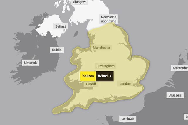
The Met Office warning is valid between 8pm on Sunday and 6pm on Monday for most of England and Wales.
Met Office Deputy Chief Meteorologist Stephen Kocher said: “Strong west or southwesterly winds will arrive across coastal areas of southwest England and Wales during Sunday evening, spreading inland and eastwards during Monday morning.
“Gusts of 45-55 mph are expected widely in inland areas, while gusts of 60-70 mph are possible at times along exposed coasts and hills.”
Ahead of these strong winds and heavy rain, there will continue to be lots of showers and some thunderstorms on Saturday.
Sunday will start bright but heavy outbreaks of rain will spread to all areas, becoming increasingly windy with gales developing in the south and west of the UK.
Residents have been urged to prepare for power cuts and travel delays, with coastal communities warned of large waves.
What should I expect?
- Some delays to road, rail, air and ferry transport are likely
- It’s likely that some coastal routes, sea fronts and coastal communities will be affected by spray and/or large waves
- Probably some bus and train services affected, with some journeys taking longer
- Some short term loss of power and other services is possible
- Delays for high-sided vehicles on exposed routes and bridges likely
Hour-by-hour forecast
Saturday, September 13
Midnight - Heavy rain - 90% chance of rain - 12C
1am - Heavy rain - <95% chance of rain - 11C
2am - Heavy rain - <95% chance of rain - 11C
3am - Heavy rain - <95% chance of rain - 11C
4am - Heavy shower night - 80% chance of rain - 11C
5am - Light shower night - 50% chance of rain - 11C
6am - Partly cloudy night - 40% chance of rain - 10C
7am - Sunny intervals - 40% chance of rain - 10C
8am - Sunny intervals - 40% chance of rain - 10C
9am - Sunny intervals - 40% chance of rain - 12C
10am - Light shower day - 50% chance of rain - 13C
11am - Light shower day - 70% chance of rain - 14C
Midday - Heavy shower day - 90% chance of rain - 14C
1pm - Heavy shower day - 90% chance of rain - 14C
2pm - Heavy shower day - 90% chance of rain - 14C
3pm - Heavy shower day - 90% chance of rain - 14C
4pm - Heavy shower day - 80% chance of rain - 14C
5pm - Heavy shower day - 80% chance of rain - 14C
6pm - Heavy shower day - 90% chance of rain - 13C
7pm - Heavy shower night - 90% chance of rain - 13C
8pm - Heavy shower night - 90% chance of rain - 12C
9pm - Heavy shower night - 80% chance of rain - 12C
10pm - Heavy shower night - 80% chance of rain - 12C
11pm - Heavy shower night - 80% chance of rain - 12C
Sunday, September 14
Midnight - Heavy shower night - 70% chance of rain - 14C
1am - Light shower night - 60% chance of rain - 13C
2am - Partly cloudy night - 40% chance of rain - 13C
3am - Partly cloudy night - 40% chance of rain - 13C
4am - Partly cloudy night - 30% chance of rain - 12C
5am - Partly cloudy night - 20% chance of rain - 12C
6am - Clear night - <5% chance of rain - 11C
7am - Sunny day - <5% chance of rain - 11C
8am - Sunny intervals - <5% chance of rain - 11C
9am - Cloudy - <5% chance of rain - 11C
10am - Cloudy - 10% chance of rain - 12C
11am - Cloudy - 40% chance of rain - 13C
Midday - Light rain - 70% chance of rain - 13C
1pm - Heavy rain - 80% chance of rain - 13C
2pm - Heavy rain - 90% chance of rain - 13C
3pm - Heavy rain - 80% chance of rain - 14C
4pm - Light rain - 70% chance of rain - 14C
5pm - Light shower day - 60% chance of rain - 15C
6pm - Sunny intervals - 40% chance of rain - 16C
7pm - Partly cloudy night - 30% chance of rain - 16C
8pm - Partly cloudy night - 20% chance of rain - 16C
9pm - Partly cloudy night - 20% chance of rain - 16C
10pm - Partly cloudy night - 30% chance of rain - 16C
11pm - Cloudy - 40% chance of rain - 15C
Monday, September 15
Midnight - Light shower night - 60% chance of rain - 15C
1am - Light shower night - 60% chance of rain - 15C
2am - Light rain - 70% chance of rain - 15C
3am - Light shower night - 70% chance of rain - 15C
4am - Light shower night - 70% chance of rain - 14C
5am - Light shower night - 70% chance of rain - 14C
6am - Light rain - 80% chance of rain - 14C
7am - Light rain - 70% chance of rain - 14C
8am - Light rain - 70% chance of rain - 14C
9am - Light rain - 70% chance of rain - 14C
10am - Light rain - 70% chance of rain - 14C
11am - Light rain- 70% chance of rain - 14C
Midday - Light rain - 80% chance of rain - 15C
1pm - Light rain - 80% chance of rain - 15C
2pm - Light rain - 70% chance of rain - 15C
3pm - Light rain - 70% chance of rain - 15C
4pm - Light rain - 80% chance of rain - 15C
5pm - Light rain - 80% chance of rain - 15C
6pm - Light shower day - 70% chance of rain - 15C
7pm - Light shower night - 70% chance of rain - 15C
8pm - Light shower night - 70% chance of rain - 15C
9pm - Light shower night - 60% chance of rain - 15C
10pm - Light shower night - 60% chance of rain - 15C
11pm - Cloudy - 50% chance of rain - 14C