Gritters hit Lancashire’s roads as Met Office extends yellow weather warning for ice
and live on Freeview channel 276
Where will be the gritters be deployed?
Gritters are scheduled to salt priority routes in Central and South Lancashire on Friday evening (December 9).
The announcement came after forecasters predicted temperatures could plummet to -4C (25F) in parts of the county overnight.
Advertisement
Hide AdAdvertisement
Hide Ad“We will apply salt to all priority routes this afternoon and will repeat treatments overnight to keep routes ice-free as far as possible,” a spokesman for Lancashire County Council said:
“Please take great care if out driving tonight.
“Our priority routes only cover a third of the highway network and ice patches can develop even on treated surfaces caused by water run-off from fields or other sources.”
Priority roads include non-trunk motorways, A-roads which are the main routes across Lancashire and B-roads which are routes in and out of towns.


Click HERE to see the online gritting map.
Yellow weather warning for ice extended
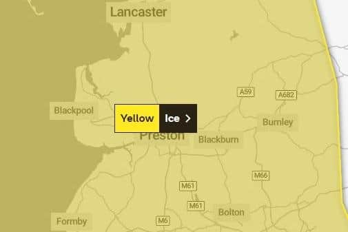
A yellow weather warning for ice issued by the Met Office was extended as forecasters predicted very cold nights and widespread frosts.


Which areas of Lancashire does the warning cover?
Advertisement
Hide AdAdvertisement
Hide AdThe warning covers all of Lancashire, including Blackpool, Preston, Lancaster, Burnley, Blackburn, Darwen and Clitheroe.
When will the warning be in place?
The warning was originally set to be in place from 4pm on Thursday (December 8) until 12pm on Friday (December 9).


It will now end at midday on Sunday, December 11.
What should I expect?
The Met Office warned some disruption was likely due to icy patches on untreated roads, pavements and cycle paths
Injuries from slips and falls on icy surfaces were also possible.
What did the Met Office say?
Advertisement
Hide AdAdvertisement
Hide AdA spokesman for the Met Office said: “Frequent wintry showers are likely to fall onto frozen surfaces in places, leading to the formation of icy patches.
“These showers are expected to fall as snow on high ground, with the potential for several centimetres to accumulate, especially over the high ground of north Wales.
“The warning area has been expanded to cover a bit more of North West England while also being extended to midday Sunday.”
