Penny-pinching postcards show Briercliffe history


Their publication underlines the fact old postcards and photos should not be thrown away. These tell us about three individual buildings in the Briercliffe area and one splendid photo is of the village of Haggate, taken from a very unusual location.
We will start with the latter which is described as “A52 Haggate (from Banks) Briercliffe”. The card was posted in Burnley on September 15th, 1906, to an address in Chapel House Road, Nelson. In this instance I know, I think, who sent it, as it is signed “Phebe”. This must have been Phebe Shoesmith and this information is fortified by the content of the note on the other side of the card.
Advertisement
Hide AdAdvertisement
Hide AdPhebe, who is writing to her unnamed cousin, says she does not think she will be able to get to Nelson on the Sunday afternoon as Mr Abraham Leaver wanted all members of the church choir to be present for the rendering of an anthem at Haggate Baptist Chapel. It is known Mr Leaver was a significant personage at Haggate Baptists in an age when it was seen as unwise not to comply with the wishes of people like him.
The card itself is one of an extensive series of postcards of Briercliffe made by the Macclesfield firm which produced postcards under the name of “Real Photograph, Saxon Series, Prestbury Road, Macclesfield”. A bit long, I know, but all their Briercliffe cards are marked this way.
I have tried to find out more about the company with an extensive internet search and visit to Macclesfield Library. The latter had not heard of the firm but, later, the helpful librarians found there were a few cards by the firm, not in their collections, but at Cheshire County Record Office. However, none were images of Briercliffe.
The reason I am interested in the Saxon Series is that there are lots of early images of Briercliffe by this firm. They are all numbered. This one is numbered A52 but the second picture published today is A53. The society has images in the A60s and it appears all of them from A2, which we also have, are of Briercliffe.
Advertisement
Hide AdAdvertisement
Hide AdWhy this should be, I do not know. However, I have a theory which runs like this: it would have cost one penny to send this card anywhere in the United Kingdom, one half penny for the card and one half penny for the stamp. However, if a letter had been sent, that would have cost a penny to post on top of which must be added the cost of the envelope and letter paper. As many people preferred to use good envelopes and the better sort of letter paper, the cost of posting a short note, such as this, would have exceeded the penny cost of a postcard by perhaps 100%!
Briercliffe people were famed for being able to recognise a bargain when they saw one and it is likely, therefore, someone in Briercliffe, or perhaps someone who had lived in, or had connections with, Briercliffe, knew there was a market for such images and had over 60 of them produced by a firm specialising in this type of work.
Who he was I cannot say, but there are several candidates who were photographers, amateur and professional, who might have had the cards made. Clearly, I need to do some more work on this but the outcome is that, for Briercliffe, there are over 60 early postcards which might not otherwise have been produced. In fact it could be that more than one person was having cards made, in some numbers, about the same time, the market for local postcards being very considerable.
Another observation might be made, and that is that Briercliffe people tended to take postcard images of Briercliffe with them on holiday when they went to Blackpool, New Brighton, Morecambe and Southport etc. At Blackpool, for instance, the holiday makers knew Blackpool trades people, being what they were, charged at least one penny for a card. This, with the postage, put the cost of sending a card up by 50%. It was much cheaper to take a stock of locally produced Briercliffe cards on holiday and send them back to family and friends with images of Briercliffe, or Extwistle, on them rather than the tower at Blackpool, another reason for the survival of so many early cards of Briercliffe!
Advertisement
Hide AdAdvertisement
Hide AdThis card shows Haggate at its hill top location from above the farm road which leads to Banks Farm, Briercliffe. The buildings at Banks, which can’t be seen on the card, are now unrecognisable from the farm that once existed on the site. In recent years new owners have made the farm house and barn into very modern properties. The old weavers’ cottages, once part of the site, have long since gone, not the fault of the present owners as the buildings were demolished years ago when cracks started appearing in some of the walls.
Behind the photographer, who took this picture, is the great geological feature of the area, the glacial overflow channel through which the farm road passes between Banks Farm and more cottages (Sparrable Row) in Banks Street, Lane Bottom, off to the right.
In the middle distance you will be able to see some lighter markings in the hillside below Haggate. These are the remains of the Hill End Colliery which operated at this site in the early 19th Century. It was re-opened, in the First World War, when there was a shortage of coal to be used at the mills of Harle Syke, a mile or so away. Almost nothing is left of the mine in this image which was taken well over 100 years ago, but, at the site, though it has been planted up by the Forest of Burnley Project, coal can still be picked up by hand!
The village of Haggate dominates its 850ft high hill, appropriately known as Haggate Hill, but I want you to turn your attention to the white painted cottages in the middle of the image. These houses are part of Chapel Row and were once used as an adjunct to Haggate Workhouse which stood on the site of the National School (the building with the big sloping roof) opposite, right. The cottages still retain the Workhouse Garden which you may be able to make out at the rear of the building.
Advertisement
Hide AdAdvertisement
Hide AdYou will be able to see that Chapel Row was not built at one time. There are four different buildings which make up the row. Beyond them, partly hidden behind some trees, is Spencer Row which was built all at the same time. It was named after the landlord of the Hare and Hounds Inn which is the lighter building to the left. The first mention of the Hare and Hounds was in 1585 when it combined the businesses of a small croft with that of an inn. At that time the road through Haggate was quite an important highway though it was by-passed by the turnpikes of the 18th Century.
On the extreme left you may be able to make out the roof of Haggate’s Methodist Church which was built in the Italianate style in 1887. Locals refer to this building, successor of the immense Thursden Chapel, as Canaan or Jehovah Jireh. It is still standing but is no longer used for religious worship.
On the extreme right of the photo you can see Haggate Baptist Chapel of 1866 and part of the Old Grave Yard, even further to the left. It was on this land the initial Haggate Baptist Chapel was founded in 1760. When this photo was taken, the Old Chapel would still have been standing but it was just out of this picture to the right. This is a great picture of Haggate. I hope you have enjoyed looking at it with me.
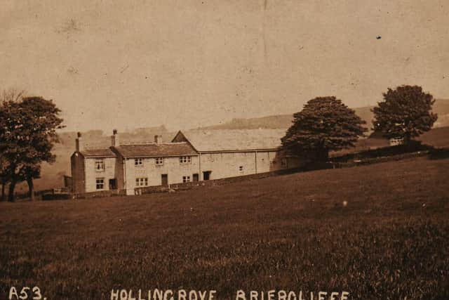
The other three pictures, I am afraid, are make-weights in that I have not got the space to go into them in much detail. The first is marked “A53 Hollingrove, Briercliffe” and, as with the image of Haggate, was produced by the Saxon Series of Macclesfield.
Advertisement
Hide AdAdvertisement
Hide AdThe card will have been made about 1900 but has not been used. It shows one of Briercliffe’s farms, the farm house, cottage and attached barn. Hollingrove means “holly wood” from the Old English holegn (holly) and the Old English graf (plantation of trees) but the farm is unlikely to go back that far (i.e. to the Dark Ages). It is first recorded in 1612 but may well be a little older. The buildings still survive but they no longer are used for farming. The barn has been converted into a house.
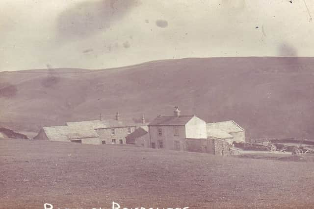
The third image is of “Rigehalgh, Briercliffe”, situated above Thursden. There are two farms shown in the picture, Higher and Lower Ridehalgh, the older being “Lower” which is first mentioned in 1296. Lower Ridehalgh is the one to the left. In the 17th and 18th Centuries buildings at this farm were used as a base for pack horses, two packs being located here until the 1820s. Another interesting thing about Ridehalgh is that the remains of an old corn kiln can still be identified here. All people who are named Ridehalgh, together with several variations, can claim association with these buildings.
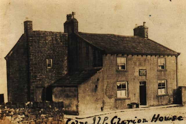
The last image is not actually in Briercliffe. It stands just beyond Coldwell overlooking Trawden but I thought you would like to see it. The details written on the card tell us the building was the Clarion House of the Colne ILP, an abbreviation for “Independent Labour Party”. There were a number of these in our part of the world. They were set up in the countryside so, after a weekend walk, or cycle ride, members could enjoy fellowship and refreshments before their return home.
I am thinking of writing a short history of the ILP as it was in North-east Lancashire as I have recently come into possession of a few other images. If you want to know what a Clarion was like go to the last surviving one between Newchurch-in-Pendle and Roughlee. It is an absolute delight.