The days of the self-employed handloom weavers in Briercliffe


The old boundary stone is still there for all to see. It is part of a raised bed maintained by Briercliffe Parish Council, a few yards from the Commercial. Close inspection will reveal the stone is not complete as it is missing the arms of the former County Borough. The stone, a substantial piece of masonry, was placed at this location in 1888/9 to mark the boundary of what was then the new County Borough of Burnley.
There was a representation of the coat of arms of that authority placed in the niche which has survived and, if you want to know what the arms looked like, travel along Ightenhill Park Lane where you will find two rather worn versions of the heraldic device near Southern Avenue.
Advertisement
Hide AdAdvertisement
Hide AdBurnley Civic Trust is keen to restore the coats of arms to these boundary stones and it is hoped the work can be carried out next year. There are a lot of things to do before that can happen but work has already started. All of the existing boundary stones have been located, and photographed, but permission to carry out work needs to be sought from the Highway Authority and, in some cases, landowners have to be contacted.
There are boundary stones of this type on most of the major roads into Burnley. These include Colne Road, Barden Lane, Ightenhill Park Lane, Padiham Road, Briercliffe Road and Hufling Lane and it is hoped all of them can be included in the project.
Getting back to Briercliffe Road, we had arrived at the Cop Row. This property is, in reality, made up of several terraces of small houses intended to be the homes of handloom weavers. There were about 40 houses in the past though that number has been reduced by the building of the Craven Heifer and the Commercial and the demolition of several cottages to create an entrance to Saxifield Street. This work was undertaken in c1902 and two and a half cottages were lost.
One of the houses still demonstrates that it was a handloom weaver’s cottage. Recently, a builder has taken the render off a gable wall and, in doing so, revealed, at first floor level, a doorway which was no longer in use. This doorway was designed to give weavers access to parts of the property used for domestic weaving. In some instances these doors not only gave access to one house but to all of them in a single block of residential property. Whether this is the case here can only be determined by examining all the properties from the inside where dividing walls would reveal whether there was access between the cottages.
Advertisement
Hide AdAdvertisement
Hide AdAlthough the power loom had been invented in the 1780s, the Burnley area remained important for both worsted and cotton handloom weaving until the later 1830s and 1840s. Therefore, cottages of this type, usually one room up and one room down, were built up to about this time. Most of them date to the years just before, and just after, the year in which the Battle of Waterloo was fought (1815). However, very few of these cottages are dated and, if they are, they are usually larger than neighbouring houses and may have been the homes of more prosperous workmen.
In those days many hand weavers were essentially self-employed. When times were good they could choose which master they would like to work for and, in the late 18th Century and up to the very early years of the 19th Century, times were, to coin a phrase “exceedingly good”. The best weavers, working on more difficult cloths, were very well paid and some Bolton weavers went around town with £5 notes adorning their hats.
Such prosperity could not, and did not, last and, towards the end of the Napoleonic Wars, the market price for almost all cloths collapsed and, with this, so did the piece rate for the weavers. After the war, piece rates - the rate a weaver was paid for a length (or piece) of cloth - continued to fall. There were lots of reasons for this but one was the increasing use of the power loom which could only operated in specially built weaving sheds.
When first invented, the power loom was a primitive machine. The first ones put to use were driven not by steam power, or even water power, but by a bull walking around a gin! Improvements to the machine, some of them by Burnley men, made the power loom more efficient and able to make an increasing number of cloths so the handloom weavers, by the 1830s, if not before, found their days were numbered. In 1833 there were over 300,000 hand weavers in the country all of whom facing financial ruin. Needless to say, they were not bailed out by the Government, as have, in more recent times, the incompetent and greedy bankers (many of whom should be long-standing guests of Her Majesty, so far as I am concerned).
Advertisement
Hide AdAdvertisement
Hide AdWe know what it was like to live in Cop Row in the trade depression of the early 1840s as of the records of a local Quaker charity have been preserved in a Manchester Library. I have referred to them before in this column and you will find a more detailed account in my “A Lancashire Township: The History of Briercliffe-with-Extwistle”.
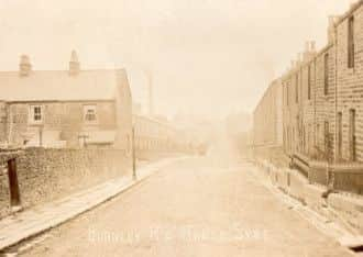
The boundary stone, near the present Commercial, was not there in the early part of the 19th Century but neither was Harle Syke. That name was applied to one of the farms on the Townley Parker of Royle estate. It was also the name of a small stream which, until recently, rose in a close of land which was part of that farm. The name of the stream can be translated as the “slow flowing stream where flax grows” and it flowed across the present site of the village of Harle Syke.
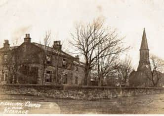
Apart from that, in 1841, for example, the only properties in what is now Harle Syke were Jackwell House Farm, Tattersall Barn Farm and the newly-built church of St James the Great. This church was built, not to serve Harle Syke because it did not exist. The reason for the church was to serve the village of Haggate, the Cop Row area, which, as we have seen, was already established, and the Jib Hill area of Lane Head, which I mentioned last week.
I realise it is difficult to think of Harle Syke without its houses, shops and mills but it must have been quite attractive as early maps show hedge-lined fields crossed by paths and one drive (for coaches and access for funerals) which led to the church. A few years later the Vicarage was built and the latter was improved with a lych-gate installed on the south of Burnley Road, just below the present Queen Street junction.
Advertisement
Hide AdAdvertisement
Hide AdOf course there was a road but, from Swamp Top, just above Lane Head we do not know, for certain, what the present Burnley Road was called. There is evidence to support the idea local people called it Burnley Lane or Mire Lane. The first is an obvious name for the largely unmade road but the latter might be a reference to its condition which, in wet weather, was pretty hazardous.
There were, for example, several places where streams attempted to cross the road. One of them was at Swamp Top and might have accounted for the name. At the site of Harle Syke, the stream, then spelled “Harlsike”, crossed to road in the middle of what is now the village. The site of its little valley can still be determined today but the stream is now culverted and, for most of its route, cannot be seen. However, at the point where the stream met the road, there was often difficulty for pedestrians and farm carts. Consequently, a little bridge was built and parts of it still survive, so far as I know, under the present road.
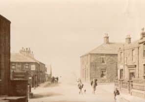
The road headed, as it still does, to Haggate, but there was only one house on the roadside, Haggate House Farm, which was where the Haggate end of the Bowling Green is now. On either side of the road here there were small quarries, Taylor Delf and Dent Delf, and one of them is now the site of the bus turning circle and the parish council’s garage colony. The other is the site of the bowling green and the Bull Field, behind.
In Haggate, the walker was soon at the crossroads where there was just one inn, the Hare and Hounds and, on the site of the Sun, the village blacksmiths. In Haggate there were several rows of handloom weavers’ cottages all of which were named. These included Spencer Row, Folly Row, Chapel Row and Edmondson’s Row. There was also a small Baptist Chapel, dating from the 1760s, which was on the Halifax Road.
Advertisement
Hide AdAdvertisement
Hide AdThis road continued to Lane Bottom and on to Holt Hill and, from there, to Thursden where it was joined by the road from Colne. Together they headed for Heptonstall and, beyond that place, to Halifax where there were important cloth markets.
Our journey along Burnley Lane has come to an end but, in a future article, I will select another road and tell you what it was like before Burnley became the town we all know today.
If you have any request for a particular road, let me know.