Negotiating mine shafts to build Burnley Bus Station in 1964


My idea is to describe the aerial view, select an area of it for more detailed study and support that with other photos taken at street level.
Today’s main image was taken in June, 1960. It shows Burnley before most of its modern buildings were constructed. However, a few of these can be identified but we ought to agree some method of determining where the buildings I want you to see actually can be found in the photo.
Advertisement
Hide AdAdvertisement
Hide AdWhat I propose – and this is merely experimental at this stage – is to divide the image into quarters, upper left and right and lower left and right. Of course, I am not going to add lines dividing the image. They are going to have to be imaginary and you are going to have to draw them in your minds.
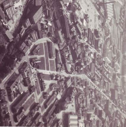
In this picture, the top left includes the Burnley embankment of the Leeds and Liverpool Canal together with the site of the present bus station. The top right quarter’s main feature is Manchester Road from the Burton’s building, past the town hall almost to the Manchester Road Canal Bridge.
We now look at the bottom left part of the image where Church Street is the dominant feature. Notice the Odeon is still standing and the Keirby newly built. The right bottom section includes Bank Parade and Bankhouse Street. It is here the remains of the Irish Park – the land had not been redeveloped since it was demolished, mostly in the 1930s – can be seen as it was in 1960.
I hope this new approach will be interesting for you. It will certainly give you a different perspective on Burnley and its history. I know it did when I started to use aerial views and this picture illustrates the point. Look at the bottom, right quarter of the image. Many of you will know the street running diagonally from St James’s Street to Bankhouse street is Bridge Street where I spent quite lot of time when I was much younger. My grandfather had one of his shops in the part of Bridge Street nearest the town centre and my father started his working life in Bridge Street, at Richard Webster’s, one of Burnley’s former department stores.
Advertisement
Hide AdAdvertisement
Hide AdI always thought of the part of the street between St James’s Street and Cannon Street, which was where Webster’s store was, but Bridge Street, and the area around it, once, had another life as home to hundreds of Irish labouring families who had come to Burnley after the Irish Potato Famine of the 1840s.
There were few Irish families in Burnley as recorded in the 1841 Census but all that had changed by 1851. The poorest streets in Burnley were soon dominated by large Irish families and so many of them found themselves in, and near, Bridge Street that the area become known as the Irish Park.
My father knew many of the families who continued to live there up to the 1930s and, occasionally, I would meet some of these wonderful and often eccentric people. They often seemed to have so little but always had time for a crack, a joke or two, sometimes a little on the risqué side but, given their circumstances, there was no point in condemning them for that.
In the plot of land, almost an island of Irishmen, which included the Drill Hall in Bank Parade, the Foresters, the Bridge Inn, the Crown Hotel, and back to Bankhouse Street, one expected Irish accents from all over that benighted country. Though I, personally, do not blame the British for what went on in Ireland in the middle of the 19th Century, I can understand why there was once so much resentment against the British among Irish people. We should note the British government had reacted in much the same way towards the English handloom weavers in the 1830s and early 1840s.
Advertisement
Hide AdAdvertisement
Hide AdI can say this because, on my mother’s side, I have some Irish blood. They did not come to Burnley at the time of the Potato Famine, they set off from Northern Ireland in the 1750s making land near St Bees, Cumbria. My ancestors had intended to meet the mainland at Stranraer, in south-west Scotland, but got swept south into England where they helped to found several villages and small towns in West Cumberland.
Anyhow, let us turn our attention to the part of this week’s image which deserves more detailed analysis. For this we are going to have to study the top, left quarter of the photo. It is the area in which we can see the Burnley Embankment, one of the “Seven Wonders of the Waterways”. To the left are the factories of Plumbe Street, but to the right, you can see that range of buildings which has featured often in the columns I write for the Express.
The half-demolished street which runs almost parallel to the canal, in this picture, is Aqueduct Street which starts with Basket Street Works, originally a corn mill, but converted, at a later date, into an iron works. The building, almost at right angles to the Basket Street Works, is the warehouse and offices of Duerden’s, the wholesale greengrocers. I wrote about them a few weeks ago.
Then, there is the Central Transport Garage which was owned by Burnley Corporation. The two large chimneys mark the Sanitary Works, also owned by the council, but better known as the Destructor Works. After that is the Burnley Electricity Generating Station which, in this picture, is followed by the large Burnley depot of Ribble Motors, the bus company.
Advertisement
Hide AdAdvertisement
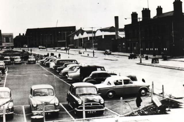
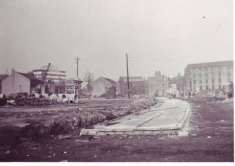
Hide AdThe open space is the site of the present Burnley Bus Station but the clearance of this land, once known as Pickup Croft (the name Croft Street comes from this), was not undertaken to build the present station. In 1964, several years after it was first mooted, Burnley’s first purpose-built bus station opened on this land.
In the late 1950s Burnley Council was beginning work on a Central Development Plan which envisaged the massive redevelopment of the shopping centre. It was thought the two bus stations – St James’s Street, for the local municipally owned buses, and the remaining parts of the Cattle Market in Parker Lane for the out-of-town routes – were not adequate for the times.
Incidentally, the magistrates’ court and police station had been transferred to part of the Cattle Market in 1955 and the out-of-town bus service providers needed better and larger facilities. This was also the case with BCN, the municipally owned bus company. The facilities in St James’s Street were inadequate for modern, larger buses, and the authorities were afraid the location of the St James’s Street bus station would continue to impact on increasing traffic.
Pickup Croft was the ideal location for a bus station large enough for both local and out-of-town providers. The council had already started the process whereby old and dilapidated properties were being acquired and demolished. I have written previously about the council’s determination in closing the Three Horseshoes, formerly a pub on the site, but as late as 1958 it was a pretty unsavoury lodging house for men.
Advertisement
Hide AdAdvertisement
Hide AdAt the time Burnley people wondered why the council was taking so long with the project. It was not generally realised it needed central funding which was withheld by the Macmillan government’s “credit squeeze” of 1961.
After what seemed a long wait, building work started and I remember local people not being able to understand what the builders were trying to do. It might surprise you to learn the building of Burnley Bus Station was one of the most difficult contracts ever let in town. There were at least three mine shafts on the site two of which were not anticipated. A few of the engineers joked that they hoped they were not in the first “double deckers” to use the station!
However, all went well and, in 1964, the first bus station on the site opened. It was a pioneering facility but not a popular one. Bus conductors (remember them?) on the long distance routes often announced their buses arrival in Burnley with the words “Burnley Bus Station, pride of the North”, but there was little to be proud of. The station was cold and windy and, so far as I was concerned, the site was nowhere near as interesting as the old one, which was adjacent to Stockdale’s toy shop, Lupton’s book shop (which also had toys) and the Lubeck Milk Bar, all three of which can be seen on this magnificent aerial view of Burnley.