History of Burnley town centre street names


We started talking about the street, where is begins, where it ends, other names by which it was known. My questioner seemed to be compensated for the question he had originally asked by the additional information which I was able to pass on.
As a consequence of our conversation, I wondered if “Peek into the Past” readers would appreciate an article covering the same ground. It might be they would be interested in the history of other streets and roads in our town? Of course, not all streets have detailed histories but some certainly do. In fact a Burnley Council official, and myself, have been collecting information about Burnley street names for years with a view to publishing it.
Advertisement
Hide AdAdvertisement
Hide AdSt James’s Street is part of Burnley’s original main street. Its origins are believed to go back to pre-Roman times when the street would have been a locally-used route determined by two crossing places on our local rivers, the Brun and Calder. These crossing places were originally fords but they were bridged at relatively early dates. The bridge on the Brun was, as it remains today, to the east of St Peter’s Church and is properly known as Burnley Bridge. The bridge over the Calder, at the bottom of Sandygate, was the original Calder Bridge and gave its name to this part of Burnley which was once known as Bridge End. The former Massey’s Brewery, which was in this part of town, was known as Bridge End Brewery.
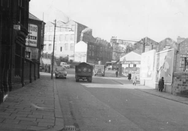
It might be useful to trace the course of the original main street and, to do so, let us start at the Burnley end, that is, near St Peter’s. This is where the original village of Burnley was founded. It was often referred to as the “Top o’ th’ Town” as it was on slightly higher ground than the property on the Burnley side of the Calder at Bridge End which was known, as a consequence, the “Bottom o’ th’ Town”.
Above the bridge over the Brun the highway was known as Burnley Lane which followed the route of the present Colne Road to Hebrew Road (also known as Old Burnley Lane) where the highway followed that road to Hebrew Bar. We now know Hebrew Bar as Duke Bar and, once there, Burnley Lane followed the present Briercliffe Road to Marsden Road where there seems to have been a junction, outside the present little fish and chip shop near the former Black Bull. One branch headed to Briercliffe, and retained the Burnley Lane name, though this part of the highway was also referred to as Mire Lane, a reference to the condition of the road. The other branch headed for Little and Great Marsden, the old names for Brierfield and Nelson.
Near the bridge by St Peter’s, the first short stretch of road was known as Finkle, or Fenkin, Street. This became Church Street which continued on its present course but the original Church Street also included the whole of Keirby Walk. This latter street, as a name, dates only from circa 1958 when the Keirby Hotel was opened. Before that Church Street continued to the top of Hall Street (or Hall Rake as it was originally known).
Advertisement
Hide AdAdvertisement
Hide AdAt this point it should be pointed out that, it is at the Hall Street junction, that St James’s Street really begins. However, on maps of the early 19th Century, the first 80 yards, or so, of the street was known as Blucher Street and the reason for that will be discussed later.
At some point before the junction with Parker Lane was reached, the name St James’s Street was introduced and this name continued to be used for the length of road to what was the cross roads at Curzon Street and Hammerton Street. After that the name changed to Goodham Hill and below that to Cheapside, that name terminating at the bridge over the Calder.
To complete the story, there was only one way out of Burnley in the old days. This was up Sandygate, which was also known as Whin Hill, and on to the Angel Inn, which is now in Accrington Road. The name Sandygate not only describes an area of town it was used for the whole length of the highway from Bridge End to the Barracks area. Westgate is a product of the turnpike era as is Accrington Road though Padiham Road pre-dates the turnpikes by some years.
So that is the route of the system of which St James’s Street is a part. I will be writing an article on the building of Burnley turnpikes in the near future and, as a consequence, will leave the complications brought about by that until then. As you can see, the story of St James’s Street, itself, is more difficult than you might have thought and, for the rest of this article, I will be referring to that street from its Hall Street junction to Bridge End.
Advertisement
Hide AdAdvertisement
Hide AdFirst, the other names by which this stretch of road has been known. I mention the name Blucher Street, when I am giving local history talks, and listeners are often surprised as it is a name with which they are not familiar. However, in street name history, one has to be aware of what has happened in national and local history when street names first emerge.
Burnley is no different to other towns in this respect but Burnley has some excellent examples of street names being associated with historic events. The two most obvious are the Napoleonic Wars and the Crimean War and it is from the first of these that Blucher Street took its name.
At the time, the early 19th Century, Burnley was emerging into the industrial town we now know and new streets were being constructed at a considerable rate.
The actual site of Blucher Street was not new but it was decided to rename part of what we now know as St James’s Street in honour of Gebhard Leberecht von Blucher, 1742-1819, otherwise known as Prince Blucher. He was a Prussian Field Marshall who fought against the French in 1793 and 1806, and in 1813 took command in Silesia defeating Napoleon at Leipzig, entering Paris (1814). In 1815 he assumed the general command of the Prussian forces, was defeated at Ligny but completed Wellington’s victory at Waterloo, also in 1815.
Advertisement
Hide AdAdvertisement
Hide AdBlucher Street, therefore, was named in honour of the Prussian (German) general who helped in the final defeat of Napoleon. When news of the victory at Waterloo reached Britain the relief that Napoleon had finally been defeated was felt by everyone. It was natural for the people of Burnley to name a street after the man who turned a defeat into a rout and the name Blucher Street was used for a short stretch of Burnley’s main street for two generations. The street reverted to St James’s Street when that street was reconstructed in late Victorian and Edwardian times.
The next of these old names is Goodham Hill. This started at Curzon/Hammerton Street running in the direction of Bridge End to just beyond Cow Lane. On the south side of the street there was a large cotton mill on Goodham Hill. It was roughly where the Empire and Vic, both in poor condition but still there, are today. On the north side of Goodham Hill, the first building was the Royal Oak Hotel, in its day one of Burnley’s more important hostelries, though the site is now occupied by Marks & Spencer’s store.
Unfortunately, I cannot tell you why Goodham Hill was so called. Even the “hill” part of the name is a problem because, as you will know, there is no such thing apparent, at least not now. However, in the past, there was something of a hill at this point on the road. It was perhaps only a gentle one but the road, at one time, did slope down to the river, especially before the present bridge was built. As for the Goodham element, I wonder if any of you know why it was used?
The last of the old names is Cheapside of which, in the past, Burnley has had at least two. I ought to add that historically only one of them was in Burnley, the one we are looking at today. The other was in Habergham Eaves and was part of what is now Padiham Road in the area of the George IV.
Advertisement
Hide AdAdvertisement
Hide AdCheapside, the name, is usually associated with commerce and trade. The word literally means “market place” from the Old English “ceapon”, to buy. We get the words “chapman” and “chapbook” from the same source, a chapman being a tradesman and a chapbook being his notated business dealings. There are Cheapsides in many English towns though both of the Burnley examples have now ceased to be used.
The question is, however, how did the Burnley example come to be used for the last stretch of St James’s Street? It is clear the road here was used for trading on a small scale from very early times. As the natural crossing point of the Calder there were businesses like inns (the Cross Keys being the oldest, though there were others) on this stretch of road but the Bridge End area of Burnley cannot be described as a town in the Dark Ages when the word was introduced into England.
The Bridge End area was settled by the 17th Century and was developed with the coming of industry and the turnpike in the 18th Century.
In the early 19th Century there was a lot house building, especially in Sandygate, and some industrial investment along the course of the Calder. In addition we should not forget about the agriculture of the Bridge End area that survived long into the 19th Century. We still have agricultural names associated with Bridge End, the Meadows, the Orchard and the Sheepfields. It could be that an old farm house still survives in the area, close to the river.
Advertisement
Hide AdAdvertisement
Hide AdSo there would have been shops in the area and, added to that, we know that in the 19th Century there were one or two markets in the (Lower) St James’s Street area. These were unofficial as Burnley Market was the only official market but we know they survived as do their descendants, the “pound shops” of this part of town. Those who object to pound shops do not, I am afraid, know their local history. We have always had their equivalent.
Lastly, reference to why St James’s Street is so-called? I have to admit I do not know, but I have my theories. I will let you have them in a future article but if you have any ideas, please let me have them.