Delving into the history of one Burnley street


However, I can only write about parts of town for which I have illustrations.
Recently, a reader has contacted me about the Sandygate area, before parts of it were demolished in the 1930s. My correspondent was particularly interested in Pitt Street, asking me if I had a picture of that street.
Advertisement
Hide AdAdvertisement
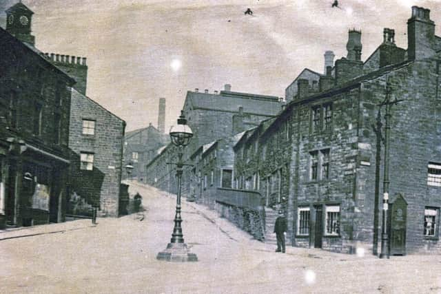
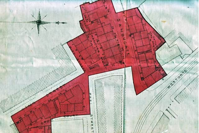
Hide AdWell, I can do better than that as not only have I got a photo of the street, taken just before it was demolished, I have got an old map which shows just where Pitt Street was. These images accompany this article and I also include an image of Sandygate, taken admittedly before this time, but useful to give a wider picture of this part of Burnley many years ago.
The map was drawn up by officers of Burnley Corporation under the provisions of the Housing Act 1930. You will see the work carried out by the council involved the town’s medical officer of health and the borough engineer. Arthur Race, who held the latter position, signed the map which is drawn at the scale of 41.66 feet to the inch. Let us start with the map. As you can see, it is very detailed. The shaded areas are the ones that interest us but, before we look at these, I wanted to know a little more about the areas that are not shaded. There had been a little demolition between 1910 and 1930 in Crow Nest, a street you can see at the bottom, left, of the map. I refer to the almost square patch of land bounded by Crow Nest, Crow Court and Peel Street.
On the other side of Peel Street, there is a block of property which is also not shaded. In this instance, the buildings were not intended for demolition at this time so there is not the detail for them that is shown for the ones intended to be demolished.
You can see the buildings intended to be pulled down are drawn in detail, their street numbers given at the front of each house individually.
Advertisement
Hide AdAdvertisement
Hide AdAs I was asked about Pitt Street we should locate it. The street is on the extreme left of the upper shaded block. It consisted of four houses, numbered 1 to 7 on the map, three of which you can see in the photo.
A little girl sits on the steps of number 1 Pitt Street but what you can’t see, at least from the photo, is that these four small houses were built in the shadow of the huge Burnley Iron Works. This is marked, on the map, to the left of Pitt Street and, if you want to see, by how much the street was overshadowed its neighbour go to the site. Burnley Iron Works still survives, though now it is known as Newtown Mill after an engineering works that once occupied the premises.
I can tell you who lived in Pitt Street in 1927, some years before it was demolished. At number 1, Mrs M.A. Sherry was the occupier. Number 3 was home to Mrs J.A. Haslam; number 5 to Mrs C. Lavin, who may be the lady in the photo. At number 7 the occupier was H. Cook, a motor driver. The ladies were all widows.
The street was still standing in 1933 by which time some of the residents of 1927 were no longer there. As is often the case, there may be an inaccuracy here but the residents in 1933 are given as: number 1, Miss R. Sherry; number 3, Mrs J.A. Haslam; number 5, Mrs M.E. Sherry and number 7, Mrs A. Gaffney.
Advertisement
Hide AdAdvertisement
Hide AdThe houses in the photo of Pitt Street were typical of the properties built in Burnley for its workers in the early part of the 19th Century.
I have not researched their actual date but they are a little better than some of the properties you can see in the image of Sandygate.
Of course, Sandygate was one of Burnley’s (or should I say Habergham Eaves) older streets. All the streets to the west of the River Calder were strictly not in Burnley, but in Habergham Eaves, and all of the properties shown today were in that parish.
I recently wrote about the gawmless lamppost at the junction of St James’s Street and Manchester Road, but I mentioned the one in Westgate and you can see it, standing in the middle of the road, just like its more famous namesake.
Advertisement
Hide AdAdvertisement
Hide AdIn this picture, we see Sandygate looking in the direction of its canal bridge. The clock of Clock Tower Mill can be seen, extreme left, and, below it, is the property which is not shaded on the map. As you can see, the building was a row of quite sizeable shops which occupied the block of property between Crow Nest and King Street.
Mentioning streets, you might have noticed a theme with regard to some of the names. King Street refers to King George III, who was on the throne from 1760 to 1820. Peel Street refers to the first Sir Robert Peel, father of the Prime Minister. The Sir Robert commemorated here is the man who managed to get the Health and Morals of Apprentices Act through Parliament. Pitt Street refers to Pitt the Younger, who was Prime Minister at the end of the 18th Century to the beginning of the 19th. It was given to him to face the might of Napoleonic France and, though he did not live to see it, he was the victor.
One other thing worth pointing out is that the map shows several examples of back-to-back housing. Pitt Street itself is an example, the odd numbers in Pitt Street itself, with the even numbers in Hanover Street where there is another row of back-to-back houses, the even numbers being in Sandygate. If you look at the photo of Sandygate, find the two windows in the gable end of a property, middle left. This is the Sandygate end of the back-to-back property, part of which is in Hanover Street.
If you would like information about any of the streets of Burnley, let me know. I cannot promise to have a picture or map, as I had in this case, but I will see if I can find out some information about the street for you.