Days when Burnley was a charming little village


Since then, a number of people have contacted me and told me how much they enjoyed the short programme. They added they did not realise just how interesting that part of Burnley remains and how much has survived from the past.
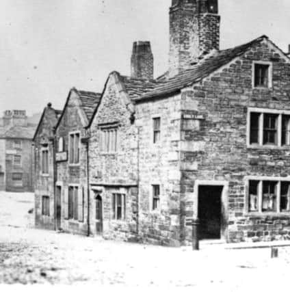
Church Street, as it is with many other Church Streets in other communities, is Burnley’s oldest street. It was, and remains, the street which led from the south to the “church” of St Peter and, over the years, other streets were added to the original.
Advertisement
Hide AdAdvertisement
Hide AdOne of the first was Godley Lane, the lane which led from the church to the village’s open fields. Another was Fenkin (otherwise Finkle) Street which was the name for Church Street on the north bank of the Brun and the last of the early streets was Cuckstool Lane which followed the short course of the present School Lane.
This article is not really about street names but, as the meanings of a few of these early names are interesting, please excuse this little diversion. “Godley” strictly means “God’s field” or “God’s clearing”. It could mean the land had been owned by the Church and indeed that is a likely derivation as quite a lot of land in the centre of the old village of Burnley was owned by the Church in the form of the Abbey of Whalley. In fact the abbey had a small grange in Church Street. Godley Lane followed a similar route to the modern Ormerod Road and the bridge over the canal, above the Thompson Park gates, is still known as the Godley Bridge.
Fenkin Street is a little more complex. The only realistic derivation of the name is Norse in origin and it refers to a bend, as in the bend seen in an elbow. This could mean the original Fenkin Street, which is the name for the continuation of Church Street from the north bank of the river to roughly where the Grammar School Gardens are now, got its name as there was a bend in the lane. This would seem to be probable and there is a slight bend to the right in the road today.
Cuckstool Lane is pretty easy. It could mean only one thing – there was a ducking stool somewhere along what is now School Lane. A ducking stool was a medieval form of punishment though its origins lay in the fact that at first “ducking” was used to determine whether someone was innocent of a particular charge or not. We know this as “trial by water” which was practiced by both the Saxons and their enemies the Vikings. In later years ducking appears to have been commuted, if that is the right word, to punishment only, talkative women often the victims. Burnley’s ducking stool seems to have been located at the top of the lane a little beyond the site of the Old Grammar School.
Advertisement
Hide AdAdvertisement
Hide AdBefore we leave the subject of Burnley’s early street names we should not forget there were at least two other early streets in Burnley. These were Bridge Street and Mill Street both of which led to the ancient corn mill which was situated between the little village of Burnley, on the Brun, and Bridge End, otherwise Windle, a small collection of properties on the river Calder at the bottom of what is now Westgate.
Bridge Street gave access to the mill from the road, now St James’s Street, which linked Burnley and Bridge End. Mill Street, in the early days little more than a path, gave access to the mill from the north where there was a series of paths which connected Burnley to the farming lands of Royle, Barden and further afield.
It was this connectivity which gave Burnley its ultimate pre-eminence in this part of Lancashire. The road which linked Bridge End to the village of Burnley was the main road in the district but, as early as the Middle Ages, there were others. Burnley was linked to the towns of the West Riding of Yorkshire by the Long Causeway which ran from Towneley towards Heptonstall. There was another road, which led from Gannow to Rochdale and on to Manchester and a route led through Ightenhill to Higham, Whalley and Clitheroe. The road from Bridge End led to Padiham and then to Blackburn and Preston.
However, Burnley was not in the same league as Blackburn which gave its name to our part of East Lancashire. In early documents the area is called Blackburnshire, though, properly, Blackburn, along with Leyland, Salford and other towns, was one of Lancashire’s “Hundred” towns in that a division of the county was known as the Hundred of Blackburn. In later years Burnley grew into having the leading role in the Upper Division of the Blackburn Hundred whereas Blackburn itself retained that role for the Lower Division.
Advertisement
Hide AdAdvertisement
Hide AdIt is not possible to compare Burnley with a number of other Lancashire towns. Preston, though it was not large on a national scale, was on what we would call the A6, Lancashire’s equivalent to the Great North Road which passed through Yorkshire. The same applied to Lancaster, Wigan and Warrington. It was the road that made these places. Burnley did not have anything like the traffic of the west of the county.
Whereas Preston, Lancaster, Wigan and Warrington became towns at a relatively early date Burnley remained a village serving a wider community in one of the less populous parts of the country. Its local rivals were Colne and Padiham but Burnley had a few advantages, not all of which applied to these other towns.
First Burnley had a relatively easy crossing point on its river, the Brun. This was where Church Street crossed the river becoming Fenkin Street. For many years there was no bridge and it was not until the 17th Century when one was built. The bridge at Bridge End, over the Calder, and the smaller one by the Corn Mill, were older.
Then the incised meander in the Brun, just above Burnley, was significant as it had given the early village protection against attack in the lawless times often experienced in what we call the Dark Ages.
Advertisement
Hide AdAdvertisement
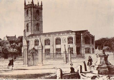
Hide AdAnother advantage was the church of St Peter which, in actual fact was not a church at all, but a chapel of the great parish of Whalley. The first reference we have to St Peter’s is in the early 12th Century but it is likely there was a church or chapel before that. There is an important difference between a church and a chapel in that the latter denotes that the place it serves is not an independent parish with its own vicar. Burnley was a chapelry within the parish of Whalley and was served by a curate, otherwise known as a parson, who lived in a parsonage. If you want to see a parsonage, there is one in Newchurch-in-Pendle. Burnley’s was on Keighley Green, where the present St Peter’s Health and Leisure Centre stands today. There were no churches or chapels in any of the small townships around Burnley, with the exception of Ightenhill, until after the Middle Ages.
Burnley had the status of a Township within the Manor of Ightenhill. In other words Burnley did not have its own Manor House, the centre for administration; it had to share the facilities at Ightenhill with a number of other townships which collectively made up the Manor. However, Burnley had the Manorial corn mill, the official market and fair for the area and was just about big enough to exercise some independence in a few of the matters that might normally be the province of the Manor. This was most apparent in the regulations which governed the agriculture of the township.
Though, in the Middle Ages, Burnley might not have the local court it did have at least four means of local punishment. Serious crimes were tried in Lancaster but Burnley did have, as we have seen, a ducking stool together with a set of stocks, a whipping post and a small lock-up prison. All of these were located around the church of St Peter in Burnley, the area which became known as the Top o’ th’ Town (Top of the Township). There was, so far as we know, nothing of a similar nature in the Bridge End area which was “Th’ Bottom o’ th’ Town” but it is known some of the other townships had stocks. The one at Cliviger has survived.
When these “facilities” are added together we can see why Burnley became the pre-eminent village in the immediate area. In those days attendance at church was compulsory, the market was held on a weekly basis and the fairs, though strictly annual, developed into fairs for horses and markets for sheep and cattle which were held more regularly. The concept of a fun fair is more recent but even ancient fairs and markets attracted entertainment.
Advertisement
Hide AdAdvertisement
Hide AdBurnley, as a consequence, became the place where traders came to carry out their business. The first to benefit were those who realised they could get some additional money by supplying refreshments. Burnley’s first inns were in the Top o’ th’ Town area and it was in this part of the Township the first shops were established. Unfortunately, we know very little about these shops but, if they were like other shops in other similar communities, some would have been general stores, others might have specialised as butchers and we know there was an early baker because, in 1425, he made some bread which was thought to be less than wholesome and found himself in court for his offence. It was fairly common for the brewers of beer to be in that position.
So Burnley developed, at first, into the most important village in this part of north east Lancashire but that was all it was until not much more than 200 years ago. The facilities that were available at the site made the early village.
It was additional resources that contributed to the further development of Burnley and the most important of these were the further harnessing of water power, the exploitation of coal, the products of local agriculture, particularly wool and leather, and the resourcefulness of its people. The great industries with which Burnley became associated in the 19th Century are all based on these four considerable resources.
Up to about 1760 Burnley remained the charming little village it had been for centuries. Its two village greens remained substantially unaltered and its woodland was almost unchanged in half a millennium. Those who visited Burnley, to this time, and for a few decades more, usually remarked on the pleasant wooded valley in which the place was located. Little did they know that things were about to change.