Changing face of Burnley’s Manchester Road


Some of the images first saw the light of day as postcards but others come from a wide variety of sources, the Burnley Express, Burnley Council, and various private photographers, the most significant of whom was the late Ken Bolton who had a life-long interest in recording changes which have taken place in Burnley.
I know of sites that Ken photographed three or four times. The first, chronologically speaking, would be of a location which may not have changed in the 80 or 100 years since it was first built. The next would record its demolition. Another would indicate a new building and there might be a fourth which would show the site redeveloped once more.
Advertisement
Hide AdAdvertisement
Hide AdFor instance, the Keighley Green area was dominated by large mills and a huge maltings. There were poor residential buildings along Massey Street and, of course, the Police Bridge. This is what the area looked like when Ken took his first pictures but when the “original” buildings were replaced Ken was there, first to record them and their demolition and then to take images of their replacements, Church Street multi-storey car park and Keighley Green Club. He was there, too, when these buildings were demolished in preparation for the present St Peter’s Centre.
You can see how useful Ken’s collection is to historians of Burnley but all his work would have been wasted had he not made arrangements for its safe keeping when the time came that he could not look after it. He gave literally thousands of images to the society with the instructions they should go to Burnley Library where the Ken Bolton Photographic Slide Collection is available for all to use.
As most of the images are in the form of slides – he gave hundreds of talks on Burnley’s history – they are more difficult to use than they might otherwise have been. However, Ken’s talks, which were very popular for years, were themed – particular streets, like St James’s Street or Manchester Road; or he would take his listeners around a district,ie Lanehead or Sandygate and show them how the area had changed or, perhaps he would undertake a pictorial tour of Burnley’s pubs or cinemas.
Today we are going to look at Manchester Road. I divide this area into “upper and lower” categories, the dividing line being the bridge over the river Calder by the town hall. This is an appropriate division as the river used to divide the township of Burnley from its neighbour, Habergham Eaves. Above the river and you were in Habergham, below, and you were in Burnley.
Advertisement
Hide AdAdvertisement
Hide AdUnlike almost all other towns where the town hall is in the centre of town, Burnley’s Town Hall is only just in Burnley. You could say it is the first building in town, or, depending on your point of view, it might be that you regard it as the last!
The first picture has been in my collections since I was a student at Manchester University in the late 1960s. When I was there I had to do historical research. I chose to work with Alfred Edward Musson, one of the leading historians of the early engineering industry. I was interested in the history of textile engineering in Burnley and North-East Lancashire and, on hearing this, he took me on.
The photo shows one building many of you will remember, Burnley’s old fire station but, next to it, the roofless building is Lane Bridge Foundry, the building in which Burnley’s first power looms were made by the almost-forgotten firm of Graham & Shepherd. Of course, these buildings have gone but the smaller property at the corner of Saunder Bank and Manchester Road is still there. It had been built as houses which were later converted into the offices of architects Samuel Taylor, Son & Platt who designed a number of buildings including the Central Methodist Church in Hargreaves Street. Very much of its time, the church is not my favourite building but it performs a valuable role in town.
We now walk up Manchester Road and turn to look back at the town centre. The picture shows Manchester Road Sidings as they were over a century ago and, though the image has faded, there is plenty to see. In fact the image was originally on a glass plate and could only be seen in negative but Ken managed to get what you can see here from what was a very dusty and dirty plate.
Advertisement
Hide AdAdvertisement
Hide AdThe next picture is a more recent version of the same scene. This time we see interesting houses on the other side of Manchester Road. At one time this section of the road, one of the more recent highways in Burnley, was known as South Parade and next two pictures show you what South Parade evolved into by the 1950s.
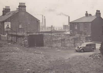
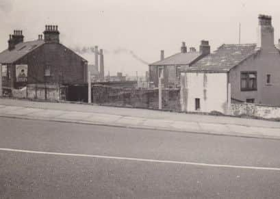
The first shows us what the Borough Hotel looked like in 1954. The building is still standing today but is no longer a pub. We have another view of the same building but taken from a slightly different angle. I have included this because you can better determine where we are by taking into account the pavement in Manchester Road. Of course, today this site is being redeveloped as part of Manchester Road railway station improvement scheme.
The next photo is taken from the Burnley Express archives and gives us a view down Manchester Road from the end of Trafalgar Street as it was before 1965. These buildings looked down Trafalgar but you can determine where they were by the location of the town hall.
We conclude this selection from the (upper) Manchester Road area by looking at photos of the area around the Bull & Butcher. I hope the first set of images print satisfactorily as it is taken from a Burnley Express calendar of the middle 1950s. The image below shows the inn before it was modernised and the picture informs us what the building was intended to be, a farm house, with cottages and barn.
Advertisement
Hide AdAdvertisement
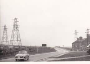
Hide AdThe next picture shows part of the drag up Manchester Road with an advertising board announcing the proximity of the Bull & Butcher. This is followed by a photo, taken by Burnley Corporation about 1960. The Bull &Butcher, left, is dominated now by ugly electricity pylons. I can remember the days when it was pylons rather than wind farms which elicited opposition from the public. The information on top of the image is a planning application number.
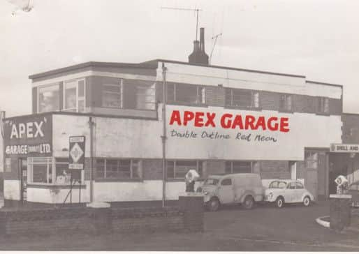
In the ninth image you will have seen signs, in the bottom right corner, advertising Shell. The last picture reminds us of the building they were referring to, Apex Garage. Long since gone this was once a well run garage and service station but, in later years, the garage was abandoned and the site became a considerable eyesore. This picture was taken in 1961.