Canalside area of Burnley is full of history


The Canalside community has a particular interest in the Top o’ th’ Town, Scar Top and Hill Top areas and, this week, we are going to concentrate on the last two. Scar Top and Hill Top are names which, in recent decades, have fallen into disuse and, if asked, many locals will not know anything about them.
The first thing, therefore, is to tell you where they were. You will see both areas marked on old maps and there was a time when all people from Burnley knew exactly where Scar Top and Hill Top were. In more recent times the map-makers often do not mention either of the districts.
Advertisement
Hide AdAdvertisement
Hide AdScar Top was the area south of Adlington Street, which is off Church Street, in Burnley town centre. It covered the area between Church Street and the Leeds and Liverpool Canal and contained streets such as Well House Street and Engine Street. The name Scar Top possibly derives from a fine Georgian house, Scar House, which stood, in its own garden, in Church Street, but I am not sure where the word “scar” comes from. It could be that the house looked towards the River Brun which, at this point, was well below the usual level of the land and in a deepish cutting, or scar.
Hill Top is even more of a problem so far as the derivation of the name is concerned as there is not much of a hill in this part of town. This, however, would be to forget what the area looked like before more modern times and some of the pictures selected today hint at a slight incline, if not a hill, in the area. Hill Top covered the narrower stretch of land between the lower part of Church Street and the canal near the Culvert. The former Gunsmith Lane might be regarded as the southern boundary of Hill Top and its most important streets would have been Hill Top Street and Maltkiln Street.
In the past both Scar Top and Hill Top were quite similar in that they contained both industry and housing. There was a large cotton mill, which was accessed off Adlington Street, at Scar Top. This was Scar Top Mill and Jack Nadin, in his “Burnley Cotton Mills”, indicates it can be traced to 1843. It is likely to be a little older.
There were other industrial premises in this area in the early part of the 19th Century as is evidenced by the name of Engine Street which was just to the west of Scar Top Mill. A rope walk, a factory for the making of rope, occupied the canal bank from the top of Forest Street to just below Scar Top Mill.
Advertisement
Hide AdAdvertisement
Hide AdHill Top contained the huge Hill Top Mill and the tall Rishton Mill and the latter reminds me that an alternative name, before the building of the canal, for this part of Burnley, was Rushton, though I am not sure why. It has been suggested there was a farm, or croft, of this name in this area in the 18th Century and Rishton is a corruption of that name. At the top of Maltkiln Street, there was the Hill Top Corn Mill. You can still determine its site as it jutted into the canal bank.
For those of you whose memories don’t go back to those days, it might help you if I explained that the Odeon cinema was built on the site of the Hill Top and Rishton mills, just before the Second World War. When the Odeon was eventually demolished it was developed by Sainsbury’s as their first Burnley store which, in more recent times, has been occupied by TK Maxx and others.
The housing in both the Scar Top and Hill Top areas often left much to be desired. The streets between Forest Street, in the north, and Adlington Street, in the south, are of the later Victorian period and many, though not all, of them have survived. However, the houses to the south of them, and towards the former Gunsmith Lane, which ran from Church Street to the Culvert, were among some of Burnley’s earliest industrial houses.
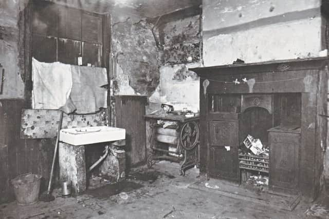
A number of them were “one up, one down, back-to-back” properties in the proper sense of the phrase. By this I mean the houses were not through dwellings; the buildings were divided in two at the roof line, one family having the “front” half of the property, another, the “rear”. The houses had only one door on each elevation which gave access to only one room at that level. This room was a kitchen/living room and contained stairs which gave access to a single bedroom, above. This arrangement was repeated in the property on the other side of the dividing wall.
Advertisement
Hide AdAdvertisement
Hide AdSome of the houses also had attic bedrooms, giving them three rooms and many of them, built in rows as most of them were, had properties on three sides. Other houses of this type had cellars, sometimes occupied as separate dwellings. One of the pictures I have chosen today shows the interior of such a property just before it was demolished in 1933.
It is not easy to get a sense of what the Scar Top and Hill Top areas were like in the past when visiting them these days. The area has been redeveloped (on some sites more than once and generally not very attractively) and it is now home to the TK Maxx store, already mentioned, a large car park, Sion Baptist Church and a Wynsor’s shoe store. There is even an underpass from St Peter’s Leisure Centre (under Church Street) which emerges near Wynsor’s.
All that said, there are still a few things to look for - the restored lime kiln in the canal bank, the long narrow site of the rope walk and there is plenty to discover on the line of the canal.
The Canalside Community Centre will be open on Saturday and Sunday from 11am to 4pm. There will also be guided tours of St Peter’s Church, and the neighbouring Top o’ th’Town area, around the church, on Saturday from 2pm.