Ancient routes taking us into Yorkshire


The route passed through what is now Towneley Park and made its way to Mereclough following, almost exactly, the present route to Heptonstall and on into what was formerly the West Riding. To get to this route, in the early 19th Century, there was a turnpike which left Burnley via Gunsmith Lane and Yorkshire Street, then known as Eastgate, and headed for Yorkshire by what is now known as Brunshaw Road.
However, there were other routes. The first of these was from Burnley, via Burnley Lane as described last week, to Little and Great Marsden, on to Colne and then Skipton. From Colne to Skipton the present road, which is an 18th Century turnpike, was not in existence but a much older one which survives which takes the high route from Foulridge to near Skipton. Another alternative to get to the White Rose County was via Briercliffe, a much more precarious route than either of those already mentioned.
Advertisement
Hide AdAdvertisement
Hide AdYou will have noted I have not mentioned Todmorden Road, the subject of our “Roads of Burnley” article today. This is because Todmorden Road is relatively new. It first appears as Fulledge Road in the 1820s and, at one stage, was also known as Burnley Wood Road. The name Fulledge Road comes from the house of that name which stood to the west of the present St Catherine’s Church and not from the district which had not yet emerged as a defined district.
This area of Burnley was on the Towneley Estate and, apart from a few scattered houses the most important of which was Fulledge House itself, the area was farmland. The undeveloped nature of the area was, in part, because the canal which, when it was constructed, in the 1790s and early 1800s, had the effect of encircling the town preventing development to the east.
The turnpike route, mentioned above, from Eastgate via Brunshaw to Mereclough and on to Todmorden, used the Culvert, which, in reality, is an aqueduct carrying the Leeds and Liverpool Canal over the road. The Culvert itself was a narrow single arched structure satisfactory for the rural area that builders had in mind when it was constructed but it would be fair to say it quickly proved to be inadequate.
At Turf Moor, not the football or cricket ground, but the horse racing track which preceded them, neither of what is now Todmorden Road nor Belvedere Road had been constructed.
Advertisement
Hide AdAdvertisement
Hide AdThe former concerns us now. In the days before the 1820s the cross roads at the former Wellington Hotel did not exist. There was, though, a Toll Bar sited across what is now Harry Potts Way. I include an old drawing of it and you will realise it is not to scale but it does give you an idea about how remote this part of town was 200 years ago.
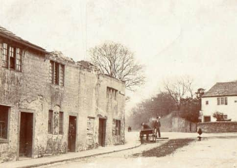
Many of you will be familiar with this site. When you are next there, examine the Cricket Field wall, which is constructed of brick, and look out for a sandstone milestone placed there by the turnpike company 200 years ago. These can be traced along the Lancashire stretch of the turnpike. Examples can be seen at Higher Red Lees and Southward Bottom, for example though the one at Pike Hill has been lost. The one on what is now Harry Potts Way has recently been restored by Burnley Civic Trust.
It seems the road which ultimately became Todmorden Road started as a footpath which led in the direction of Fulledge House. Originally, the house was little more than a yeoman farmer’s property. It had barns close to the house and fields in the direction of the river. However, the family that came to live there were fortunate to find coal on their property and sank a mine between the house and the river.
This coal mine was known as Fulledge Pit and it has a claim to be the place where Burnley’s Industrial Revolution began as one of the first steam engines, if not the very first, was installed here to pump water out of the workings. This investment proved to be a great success because the direct consequence was the founding of Burnley’s biggest industrial enterprise, the Hargreaves Collieries.
Advertisement
Hide AdAdvertisement
Hide AdThe finding of coal had something to do with the opening up of what is now the Fulledge area. There were other small mines in the Plumbe Street area and soon other industrial investments were being made. One of them was a “rope walk”, nothing of which now survives, but its site can be easily identified because it followed the exact route of the present Temple Street. Early rope works were known as “rope walks” because, to get the necessary strength giving twist into the rope, a rope maker had to walk some distance in making the rope. More modern machinery could add the twist on the spot, as it were, but it required some distance to achieve the same objective in the old days. The path of another old rope walk can be seen on the canal bank behind the car park at TK Maxx.
It was not only industry which opened up the Fulledge area. Off Todmorden Road and somewhere near its present junction with Parliament Street there was once an open air swimming pool. It is shown on Burnley’s earliest street maps which date from 1819 and its location was remembered when one of the mills in this district was built. It was known as Spa Mill, a spa being a place where the waters could be taken.
Another factor in opening up the Fulledge area was the construction of “Hanbrigg Castle”. Only part of this structure, the formal gatehouse from Burnley into Towneley Park, now survives. I will be referring to this building in another article so, here, I will only mention how it got its name. The “castle” reference is easy enough to understand because the building has something of the look of a castle even today. It is, of course, nothing of the sort, merely a gateway and gatehouse into the park.
However, the name Hanbrigg might need some explanation. This comes from a foot bridge which once spanned the Calder near the present bridge which carries Todmorden Road over the river. The second syllable “brigg” refers to the bridge. The other element “han” is a corruption of “hand”, so the name should, in full, be Handbridge. The abbreviated form, “Hanbrigg” is what the locals called it and the name stuck.
Advertisement
Hide AdAdvertisement
Hide AdHanbrigg Castle was constructed when the Towneleys were in residence and at a time when the town Burnley, to distinguish it from the borough, had not advanced to anything like its present boundaries.
The Castle would have had a fine view to the river and the fields now occupied by Parliament Street and its neighbours. Many of you will remember a number of very large textile mills were built in this area and, in the second half of the 19th Century, this bucolic view had disappeared for ever.
Carrying on along Todmorden Road, the next buildings were also associated with the Towneleys.
Perhaps the most important of these was the little Catholic Chapel which the family built on the Habergham Eaves side of the river. It replaced the chapel at Towneley Hall which had been used, not only by the family, but by Catholics from a wide area. In fact Towneley had served as a centre of Catholic dissent for many of the years after the Reformation and the creation of the Church of England.
Advertisement
Hide AdAdvertisement
Hide AdThe Chapel was built in 1817 and served the growing Catholic Community until the construction of St Mary’s in Yorkshire Street in the mid 1840s.
It might surprise some of you to learn I remember this building! Its days were not numbered when St Mary’s was completed. It was removed, “lock, stock and barrel”, as they say, to land behind St Mary’s where it became, in turn, a school, a Sunday School and a club for members of the church. It was in a very poor condition when I knew it and pupils of the Boys’ School were told, in no uncertain terms, to keep clear.
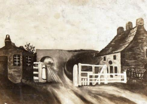
Above Hanbrigg, Todmorden Road passes through a number of quite different areas. Its junction with Hufling Lane should be mentioned as there was something of a hamlet here long before industrialisation. The only property that remains is Hufling Hall itself but the picture I include will give you some idea of what this area was once like.
In this area the road enters Burnley Wood and there are some very fine Victorian houses in this part of town. Higher up the road the site of Towneley Station can be located and the remains of Towneley Colliery can be seen. On the other side of the road we pass Causeway End and the upper parts of Towneley Park. Some of you will recall Barwise Nursery.
Todmorden Road terminates at the junction with the Bacup and Cliviger Roads and eventually this route joins the turnpike route to Todmorden.