A time before industry took a grip on our town


Today we are going to travel along Briercliffe Road as it would have been before 1827, the year of the publication of Burnley’s first reliable street map. We not going to make the full journey today but imagine a time before industry has taken its grip on our town, when much of what is now Burnley was fields and woodland. Difficult it might be, but today’s article might help you a little.
The highway we now know as Briercliffe Road has its origins in Burnley’s original centre near St Peter’s Church. For much of its history it has been known as Burnley Lane which accounts for the local name, Lane Head.
Advertisement
Hide AdAdvertisement
Hide AdIn the early days, that is, from the later 16th Century, all roads in Burnley led to the church which was the most important building in the Township. It was also the most important building in the entire district. This was because everyone had to attend the Sunday, and other services there, but, after the decline that took place, first, in the Feudal and then the Manorial Systems, the church, and its Vestry, became the centre for local administration.
The Constable had his lock-up close to the church. The Surveyor of Highways had his meetings in church property as did the Overseer of the Poor and the other local body, which had responsibility for the church itself, also met in church property. From 1559 the Grammar School was located in the vicinity of the church but, more importantly, there was a weekly market and an annual fair, held only a few yards beyond the churchyard boundary.
Before I progress I want to point out, and, given what I have written before, many of you will understand this, that St Peter’s was not really a church at all. It was in fact a chapel under the control of the Vicar of Whalley. That village was the location of Burnley’s Parish Church until the passing of the Parish of Whalley Act of 1843. Burnley was only a Township, so its place of worship could not be called a church. St Peter’s was a chapel, served, not by a vicar, but by a curate who was the Incumbent, the holder of the responsible ecclesiastical office, though he, depending on the demands on his time, may have had an assistant curate to help him.
Church Street, obviously, led to St Peter’s as did Fenkin Street, Cuckstool Lane and Godley Lane, the main streets of Burnley, along with the present route of St James’s Street, in the later Middle Ages. There were other streets, some of them not named, often merely paths which had not yet risen to the status of streets or roads. These included Mill Street and Bridge Street which were routes at an early date though their names and status came later. Another route might have been Hall Rake and it is likely there was at least a path at Rake Foot, a short path which led from Church Street to the Brun. Sandygate was too far away and, in any case, it was in Habergham Eaves not Burnley, as was much of the local end of the Long Causeway which extended right across Towneley Park.
Advertisement
Hide AdAdvertisement
Hide AdWhat we now call Briercliffe Road, though then it was known as Burnley Lane, commenced near to where, today, you will find the Old Grammar School Gardens. At that time, the Grammar School was still in St Peter’s churchyard and the Grammar School Gardens were part of a Cock Pit where the bloodier form of cock fighting, the cock-shy, was the norm. This was where the birds were killed by stoning them to death rather than the same be caused by a fight to the death between two birds. Cock fighting was a popular sport, the equivalent, perhaps, to the activities which take place at Turf Moor, though there were other sports to be enjoyed a number of which were pretty bloody as well.
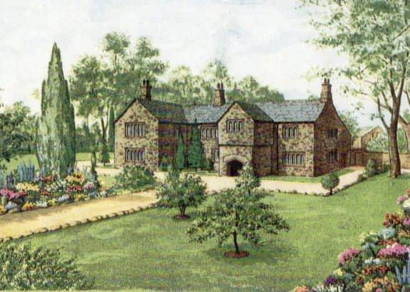
On the left there was Cronkshaw Meadows. An interesting name; cronkshaw literally means, “stork meadow”, though I have also seen it interpreted as “crow meadow” or “the meadow of poor land”. Which one is right, I can’t say, but a little further along, and visible from the road, was Daneshouse, which is also recorded as Dancer’s House. By the early 17th Century the building, surrounded by fine gardens, must have looked something like the picture which accompanies this article. It was the home of the Folds family, one of whom had been a chantry priest at St Peter’s. This was John del Folds, better known to us as John del Foldys because of his 1520 gravestone which, since 1789, has adorned the park at Towneley. It is my opinion the “y” in Foldys is really an apostrophe. His name, when written thus, meant John of the family Folds, a name which has also come down to us as Foulds.
On the right was, as is the case now, the river Brun. It would have been possible to see the river from a point opposite the site of the Cannons which were placed there in 1867 in honour of Burnley’s role in the Crimean War. However, if travelling along the road, a walker might have been able to see something of interest in the riverbank, the weir for the King’s Corn Mill. This is still there to this day and it about to be restored by the Ribble River Trust. Bank Hall, originally Bank Top, was above the weir. The building readers will remember was constructed c1780, but the earlier one, on the same site, was of timber construction and must have looked something like, though perhaps smaller, Samlesbury Hall. It was more set back from the road than Samlesbury and it might be a more appropriate comparison to mention Rufford Old Hall, near Ormskirk.
Bank Hall was the home of the Woodruff family who, by the standards of the day, were wealthy farmers. They became quite prosperous in the 16th Century probably because of the rise in the price of wool. By the 17th Century a member of the family, Isabel, married into the Shireburn’s of Stonyhurst and is mentioned on a memorial in Great Mitton Parish Church. There is also a gravestone in Burnley churchyard which records an Isabell Woodruff and I have wondered if it memorialises the same person.
Advertisement
Hide AdAdvertisement
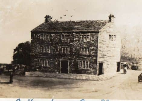
Hide AdBefore we leave these two properties, it is worth mentioning that both Daneshouse and Bank Top, as it would have been at the time, though they had flower, fruit and vegetable gardens, were places of work as well. Both were the centre of an agricultural enterprise and there were other such farms in the area before 1827. Marles Farm was one of them as was Bishop House, which were further up the road in the vicinity of what is now Duke Bar. There was another farm at Sandholme which was near the site of Bank Hall Colliery and there were residential properties, off the road we are travelling, in the area of what is now Plantation Street. These “cottages”, if that is what they were, are shown among this week’s illustrations.
Almost directly opposite the site of these buildings is Burnley Lane Chapel, formerly Ebenezer Chapel, built in c1789. It was here the original route of the road headed off in a different direction. The road followed the present Hebrew Road to a place formerly known as Hebrew Bar, but known to us as Duke Bar.
It is thought that, at first, the turnpike followed what became known as Old Burnley Lane (ie the Hebrew Road route) but, at some time, probably not long after the turnpike was opened for business, the straight stretch of road from Burnley Lane Chapel to Duke Bar was built.
At the Hebrew Road junction with our road there were some early buildings of which we are fortunate to have an illustration. The card on which they appear is entitled, “Old Houses, Hebrew Road, Burnley” and the properties were located, on the right, at the point at which Hebrew Road leaves the present Colne Road. There are three, possibly four, houses and a later shop, this on the left of the picture. From the design of the windows and chimneys, it is clear these buildings, had they been standing now, would be c300 years old. Notice there are four “doors” shown in the picture but only three cottages. There may have been another cottage out of the picture but the spare door is not a door at all but the entrance to a passage which gave access to the back of the properties.
Advertisement
Hide AdAdvertisement
Hide AdIt was, in fact the rear of these properties, that was important. Benjamin Bell was a shop keeper, but he did not have to rely on a supplier. He grew the things he sold on a large market garden behind his property. This is shown on early maps though they do not tell us what he produced. I can guess, but I would love to know.
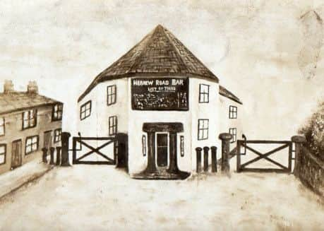
There is an interesting drawing of Duke Bar when it was known as Hebrew Bar and I reproduce it here. The perspective is wrong but you can see what this area was like before the building of the property with which we are familiar. In fact, one of my regrets is that I did not manage to take a good photo of Hebrew Road before its stone-built houses were demolished. Just a few remain and it is likely they were built early in the 19th Century, maybe a little before. It is possible many of them were handloom cottages. I know there were some in this area, and the drawing I publish, indicates a number of them might have been the homes of weavers who worked at home.
Duke Bar seems to have been something of a community in its own right. There was the toll house, which here is shown with two toll gates, though, at the beginning, I suspect there was only one because the gate on the left could not have been there. The reason for this was that the route of the turnpike went along Briercliffe Road to Lanehead from where it headed to Little and Great Marsden via Marsden Road.
Near the toll house was a pub which acquired the name, the Duke of York, after Queen Victoria’s uncle who is commemorated in the nursery rhyme which begins:
The Grand Old Duke of York,
He had ten thousand men,
He marched them to the top of the hill
And marched them down again.
Advertisement
Hide AdAdvertisement
Hide AdWhen a boy I thought this was a pretty stupid thing to do but, later, I learned there is a story to this, a real incident that took place in the French Revolutionary Wars at the end of the 18th Century. The Duke had been given command of an army. The rhyme, though, is a satire on the military inactivity of the Duke. Apparently, he had the men who were restless, like all Englishmen, to get at the French, but he was not willing to engage the enemy, marching without purpose, impressive but lacking in the results department.
I will continue my perambulation up Burnley Lane/Briercliffe Road in a future article.