Rivers helped form many of Burnley's ancient boundaries


The Boundary Commission, using criteria determined by the Government, has produced a Report, which makes proposals to change constituency boundaries.
Some weeks ago I attended, as a member of the public, a meeting of the Commission, held at the Midland Hotel, in Manchester. It was held so that people from the North West of England could comment on the proposals made by the Commission. Needless to say, I was the only person from Burnley to be present, though I met some representatives from Ribble Valley who were as opposed to the proposals that affected their constituency as I am to those which will affect Burnley, Pendle and Hyndburn.
Advertisement
Hide AdAdvertisement
Hide AdWhilst there I did not hear a single individual, wherever they were from, say that they were in favour of the proposals. It appears that the MP for Burnley is not in agreement with her local party colleagues. The latter support the proposals which will divide the present Burnley constituency in two – the larger part joining with a remnant of the present Pendle constituency to form a new, larger Parliamentary seat; the smaller part of the present Burnley constituency will be brought together with Hyndburn to create another new seat which it is recommended should be called “Accrington”.


I wonder what people in Coal Clough, for example, will think about that - living in Burnley but having to get their head around having an Accrington MP? It is more complex for the residents of Colne. The Commission recommends that they should be extracted from the present Pendle constituency and “thrown in” with Clitheroe! An examination of this new seat, a long ungainly sausage of a thing, reveals that it will, if adopted, stretch from Bamber Bridge to Laneshaw Bridge! It is not surprising that the people of both Colne and Clitheroe are united in their opposition to these proposals and that the current MP for Pendle has other ideas which would retain his present constituency intact and, add to it a large slice of the eastern parts of the present Burnley seat.
A lot of what has been said is about party politics. The bottom line is that, under the Commission’s proposals, North East Lancashire will lose at least one, possibly two MPs. In other words the present incumbents, before a 2020 General Election, will have to fight each other to retain their seats in the House of Commons. Then they will have to win an election in a new, and perhaps less predictable, constituency before they return to Parliament.
This example is given not to make a political point but to demonstrate that boundaries are important. Constituency boundaries are changed quite regularly. The decision, over 40 years ago, to get rid of the old Clitheroe constituency made a great deal of sense but it seems that the Clitheroe and Colne proposals may be just as bad, if not worse.
Advertisement
Hide AdAdvertisement
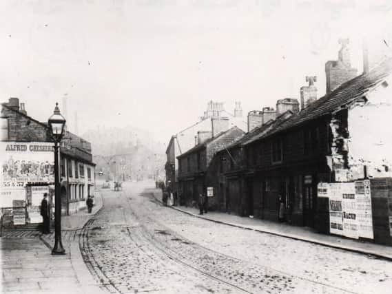
Hide AdThere are boundaries everywhere. Sometimes they are recognised. Sometimes they are not. The first picture I have chosen for today’s article comes into the latter category though there was a time when the former would have applied. The image is of St James’s Street in Burnley well over 100 years ago. It might be that you do not recognise where we are but, if I tell you that, on the left of the photograph, behind the “Alfred Cheshire” poster, the building is the Cross Keys.


This is not the building you will know today (which was built in 1906) but the one on the site up to that time. What you might not realise is that the Cross Keys, depending where you were coming from, was either the first or the last building in Burnley. Running along the side of the Cross Keys is the Lancashire Calder. The property to the east of the Calder has always been in Burnley – to the west, it was in Habergham Eaves.
The Calder is one of the important boundary rivers of our area. The boundary created by the river is the reason why Towneley Hall, and much of its park, was, historically, not in Burnley but in Haberham Eaves. It was not until 1861 that Burnley and parts of Habergham Eaves were united into one town which was given the name of Burnley. In fact, in that year, there were more people living in Habergham Eaves than there were in Burnley but Burnley had the church of St Peter’s, the Market the Fair and the shopping centre – the reasons why “Burnley” was chosen.
There is something else which you might not realise. It also involves the river Calder. You will all know where Burnley Town Hall stands, but how many of you have noticed that it is adjacent to the river Calder? Burnley Town Hall is only just, historically speaking, in Burnley. In nearby Todmorden the Town Hall stands astride the Yorkshire Calder, so it is in both Stansfield and Langfield, the historic names of the two townships of Todmorden.
Advertisement
Hide AdAdvertisement
Hide AdOne would have thought that lower down the Lancashire Calder the river would have formed a natural boundary between the places of that area. Unfortunately, it wasn’t. Ightenhill, for example, has property on both the northern and southern banks of the river. The parish actually extends as far as Higham. Some of the property one might think is in Higham is actually in Ightenhill and the owners of this property pay Council Tax to Burnley, not Pendle.
Where I live, in Briercliffe, Catlow Brook, which lower downstream is Walverden Water, provides the boundary between Nelson and Briercliffe. The River Don, which, in its upper waters, is known by other names, is the boundary between Briercliffe and Extwistle. Further south, Swinden Water, as we have seen in recent articles in this series, is the boundary between Extwistle and Worsthorne.
Rivers and streams are particularly useful to solve the problems of definition. In 17th Ccentury Burnley a problem arose about the boundary between Burnley and Briercliffe. Burnley overseers of the poor suspected that they were paying out doles to residents of Briercliffe. This they wanted to avoid so they called in an expert who happened to be working for King Charles I advising him on how he could improve the revenues of his estates in North East Lancashire.
The expert was Roger Kenyon, whose main work, in this area, was to try to make the king’s lead mine in Cliviger profitable. When approached by the overseers of Burnley about their boundary problem, Kenyon reported that he could not find one, so they put him to work to suggest one. He set to work, using his skills as a surveyor and map-maker, and he produced a report, which after a lot of “toing and froing”, was adopted. The boundary he suggested, still largely, but not entirely, exists to this day and, if you think that he might have made use of a water course, you are right!
Advertisement
Hide AdAdvertisement
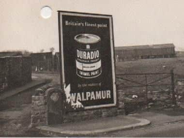
Hide AdThe second picture today shows the boundary stone on the Kenyon boundary as it crosses Burnley/ Briercliffe Road by the Commercial on the old Burnley/Briercliffe boundary. A stream, now culverted, used to flow here but, ironically, this is where the Kenyon boundary no longer applies as land to the east and the west of the old boundary has all been in Briercliffe for over 25 years.
In other articles in Retro I will tell you about other boundaries in our area.